![[New York – Jefferson County], An extensive archive of letters and documents on the creation and planning of Jefferson County, New York, Paris, etc., 1797–1877.](https://static-assets.artlogic.net/w_1600,h_1600,c_limit,f_auto,fl_lossy,q_auto/artlogicstorage/hsrarebooks/images/view/fda7f5d6f297bd9c0b8c8e05429bf33bj/hsrarebooks-new-york-jefferson-county-an-extensive-archive-of-letters-and-documents-on-the-creation-and-planning-of-jefferson-county-new-york-paris-etc.-1797-1877..jpg)
![[New York – Jefferson County], An extensive archive of letters and documents on the creation and planning of Jefferson County, New York, Paris, etc., 1797–1877.](https://static-assets.artlogic.net/w_1600,h_1600,c_limit,f_auto,fl_lossy,q_auto/artlogicstorage/hsrarebooks/images/view/755c1efe5179fa09ef29751d48d2e6e3j/hsrarebooks-new-york-jefferson-county-an-extensive-archive-of-letters-and-documents-on-the-creation-and-planning-of-jefferson-county-new-york-paris-etc.-1797-1877..jpg)
![[New York – Jefferson County], An extensive archive of letters and documents on the creation and planning of Jefferson County, New York, Paris, etc., 1797–1877.](https://static-assets.artlogic.net/w_1600,h_1600,c_limit,f_auto,fl_lossy,q_auto/artlogicstorage/hsrarebooks/images/view/d2e352f0118dee15230fc83a4538adffj/hsrarebooks-new-york-jefferson-county-an-extensive-archive-of-letters-and-documents-on-the-creation-and-planning-of-jefferson-county-new-york-paris-etc.-1797-1877..jpg)
![[New York – Jefferson County], An extensive archive of letters and documents on the creation and planning of Jefferson County, New York, Paris, etc., 1797–1877.](https://static-assets.artlogic.net/w_1600,h_1600,c_limit,f_auto,fl_lossy,q_auto/artlogicstorage/hsrarebooks/images/view/c5066da0ebf712a24f28855586cde0e3j/hsrarebooks-new-york-jefferson-county-an-extensive-archive-of-letters-and-documents-on-the-creation-and-planning-of-jefferson-county-new-york-paris-etc.-1797-1877..jpg)
![[New York – Jefferson County], An extensive archive of letters and documents on the creation and planning of Jefferson County, New York, Paris, etc., 1797–1877.](https://static-assets.artlogic.net/w_1600,h_1600,c_limit,f_auto,fl_lossy,q_auto/artlogicstorage/hsrarebooks/images/view/7837ce7f90161fbb5abd91cab26cfe69j/hsrarebooks-new-york-jefferson-county-an-extensive-archive-of-letters-and-documents-on-the-creation-and-planning-of-jefferson-county-new-york-paris-etc.-1797-1877..jpg)
![[New York – Jefferson County], An extensive archive of letters and documents on the creation and planning of Jefferson County, New York, Paris, etc., 1797–1877.](https://static-assets.artlogic.net/w_1600,h_1600,c_limit,f_auto,fl_lossy,q_auto/artlogicstorage/hsrarebooks/images/view/d681eb145e7b05bb0047096c78bdbcfej/hsrarebooks-new-york-jefferson-county-an-extensive-archive-of-letters-and-documents-on-the-creation-and-planning-of-jefferson-county-new-york-paris-etc.-1797-1877..jpg)
![[New York – Jefferson County], An extensive archive of letters and documents on the creation and planning of Jefferson County, New York, Paris, etc., 1797–1877.](https://static-assets.artlogic.net/w_1600,h_1600,c_limit,f_auto,fl_lossy,q_auto/artlogicstorage/hsrarebooks/images/view/053bac66e2a481a131844690884def98j/hsrarebooks-new-york-jefferson-county-an-extensive-archive-of-letters-and-documents-on-the-creation-and-planning-of-jefferson-county-new-york-paris-etc.-1797-1877..jpg)
![[New York – Jefferson County], An extensive archive of letters and documents on the creation and planning of Jefferson County, New York, Paris, etc., 1797–1877.](https://static-assets.artlogic.net/w_1600,h_1600,c_limit,f_auto,fl_lossy,q_auto/artlogicstorage/hsrarebooks/images/view/8c1c45cf0cc9a29889b3fc1b004b7c29j/hsrarebooks-new-york-jefferson-county-an-extensive-archive-of-letters-and-documents-on-the-creation-and-planning-of-jefferson-county-new-york-paris-etc.-1797-1877..jpg)
![[New York – Jefferson County], An extensive archive of letters and documents on the creation and planning of Jefferson County, New York, Paris, etc., 1797–1877.](https://static-assets.artlogic.net/w_1600,h_1600,c_limit,f_auto,fl_lossy,q_auto/artlogicstorage/hsrarebooks/images/view/40e87c5b0406637e7f5ea8fa6ad1de54j/hsrarebooks-new-york-jefferson-county-an-extensive-archive-of-letters-and-documents-on-the-creation-and-planning-of-jefferson-county-new-york-paris-etc.-1797-1877..jpg)
![[New York – Jefferson County], An extensive archive of letters and documents on the creation and planning of Jefferson County, New York, Paris, etc., 1797–1877.](https://static-assets.artlogic.net/w_1600,h_1600,c_limit,f_auto,fl_lossy,q_auto/artlogicstorage/hsrarebooks/images/view/b3703150ceddb31e12ed8fdd1e6b6e6dj/hsrarebooks-new-york-jefferson-county-an-extensive-archive-of-letters-and-documents-on-the-creation-and-planning-of-jefferson-county-new-york-paris-etc.-1797-1877..jpg)
![[New York – Jefferson County], An extensive archive of letters and documents on the creation and planning of Jefferson County, New York, Paris, etc., 1797–1877.](https://static-assets.artlogic.net/w_1600,h_1600,c_limit,f_auto,fl_lossy,q_auto/artlogicstorage/hsrarebooks/images/view/c5436110b976bd8c6e400fc82054a250j/hsrarebooks-new-york-jefferson-county-an-extensive-archive-of-letters-and-documents-on-the-creation-and-planning-of-jefferson-county-new-york-paris-etc.-1797-1877..jpg)
![[New York – Jefferson County], An extensive archive of letters and documents on the creation and planning of Jefferson County, New York, Paris, etc., 1797–1877.](https://static-assets.artlogic.net/w_1600,h_1600,c_limit,f_auto,fl_lossy,q_auto/artlogicstorage/hsrarebooks/images/view/7684a14b41232881d916f6400ec659bcj/hsrarebooks-new-york-jefferson-county-an-extensive-archive-of-letters-and-documents-on-the-creation-and-planning-of-jefferson-county-new-york-paris-etc.-1797-1877..jpg)
![[New York – Jefferson County], An extensive archive of letters and documents on the creation and planning of Jefferson County, New York, Paris, etc., 1797–1877.](https://static-assets.artlogic.net/w_1600,h_1600,c_limit,f_auto,fl_lossy,q_auto/artlogicstorage/hsrarebooks/images/view/00667b4567a09f057db1372954c8d664j/hsrarebooks-new-york-jefferson-county-an-extensive-archive-of-letters-and-documents-on-the-creation-and-planning-of-jefferson-county-new-york-paris-etc.-1797-1877..jpg)
[New York – Jefferson County]
An extraordinary record of land acquisition and development by French settlers in Jefferson County, New York, spanning an eighty-year period from the close of the eighteenth century to the 1870s.
Further images
-
(View a larger image of thumbnail 1
)

-
(View a larger image of thumbnail 2
)
-
(View a larger image of thumbnail 3
)

-
(View a larger image of thumbnail 4
)
-
(View a larger image of thumbnail 5
)
-
(View a larger image of thumbnail 6
)

-
(View a larger image of thumbnail 7
)
-
(View a larger image of thumbnail 8
)
-
(View a larger image of thumbnail 9
)

-
(View a larger image of thumbnail 10
)

-
(View a larger image of thumbnail 11
)
-
(View a larger image of thumbnail 12
)
-
(View a larger image of thumbnail 13
)
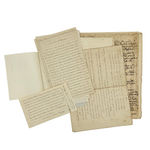


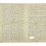
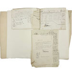
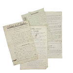
An archive comprising hundreds of manuscripts on paper in French, with a few in English, various sizes, written in ink in various hands; some tears, creases, and marks; overall well preserved; housed in an archival box.
The archive comprises maps and plans, reports and descriptions of the territories acquired, extensive correspondence between America and France, contracts and other legal documents, financial statements, and lists of landholders. The detail contained herein is truly remarkable and worthy of close scholarly study. Jefferson County was the particular target of French settlement in the years immediately after the French Revolution, and then again after the fall of Napoleon, lured by the presence of Joseph Bonaparte, Napoleon’s brother.
The story told by the archive features three principal protagonists. James Donatien Le Ray de Chaumont (1760–1840) was the son of Jacques- Donatien (1726–1803), supporter of the American Revolution and a friend of Benjamin Franklin. James became an American citizen in 1788, and, in association with Gouverneur Morris (1752–1816, Founding Father and ‘Penman of the Constitution’), acquired vast unpopulated territories in Pennsylvania and New York. James built Cape Vincent (named after his son), Theresa (named after his daughter), and LeRay Mansion (Fort Drum), and both the town of Le Ray and the village of Chaumont, NY are named after him. Le Ray, who travelled back and forth between France and America, also built roads, set up industry, and gave plots liberally to churches and schools. He established a land office in Manhattan c. 1815 (it moved to Carthage, NY in 1819) selling small tracts to French exiles; but his biggest land deal was with Prince Joseph Bonaparte, who purchased 120,000 acres in 1818 in exchange for some of the crown jewels of Spain (Haddock, The Growth of a Century: As Illustrated in the History of Jefferson County, New York, from 1793 to 1894 (1894)).
Between 1811 and 1816 James sold over 7000 acres of virgin land around Cape Vincent, bordering the St Lawrence River and facing Kingston, Ontario, to the Napoleonic general and governor of Guadeloupe, Edme- Étienne Borne Desfourneaux (1767–1849). Desfourneaux set about clearing the land with a view to constructing a new town, intended to become a commercial hub bearing his name. In 1836 Desfourneaux in turn sold much of his territory to the investor Alexandre Guyot de Villeneuve (1804–1878), and both remained closely involved in their American holdings until their respective deaths.
A host of significant secondary characters also emerge from the archive, including John B. Esselstyn, agent to Desfourneaux, and Villeneuve’s own agents, Louis Peugnet and Henry Alker. Louis Désiré Peugnet (1793–1877) was a colourful ex-infantry captain who had been wounded at Waterloo; Captain Louis Peugnet House, built c. 1837, stands to this day at Cape Vincent.
The following items in the archive are especially worthy of note:
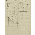
1. A map, highlighted in watercolour, showing plots of land along the St Lawrence River, copied ‘from the map filed in the office of the Surveyor General Mr Simeon de Witt, the 24th January 1797 in Albany’, and signed by Le Ray de Chaumont. The map shows Damas Bay (altered to Defourneaux Bay), the Julie River, and Langeron’s Creek. The plots are marked as ‘tres bon’, ‘bon’, or ‘modest’.
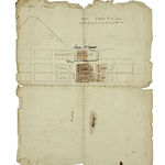
2. An undated plan for a town on the St Lawrence River at Cape Vincent, showing streets and plots for houses, and bearing the names ‘Esselstyn’ and ‘Murray’.
3. An undated document signed ‘Le Ray de Chaumont’ giving costs in dollars of clearing, sowing, and fencing his land, as well as for a barn, stable, wooden and stone house, livestock, and tools, and predicted income for a hundred-acre farm in 1812–1813; with a note also in the hand of Desfourneaux. 1 p.
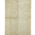
4. An enthusiastic letter (signature cut out) to Desfourneaux, written from New York on 27 August 1821, reporting on the writer’s visit to Desfourneaux’s lands; describes travelling by steamer to Albany and then by road to Le Ray and Cape Vincent; praises the roads; describes a meeting with Le Ray de Chaumont whom the writer found helpful but ostentatious; mentions the sale of 100,000 acres to Prince Joseph Bonaparte; describes trips to Damas Bay and the Julie River; mentions immigration, woodland, fish ponds, the value of the land, etc. 4 pp.
5. An undated note prepared for Desfourneaux regarding a potential associate to exploit his land and a suitable team under his management. The associate would need to be young and robust with some knowledge of chemistry, physics, mechanics, and veterinary science, as well as skill with a plane. The note discusses the qualities and equipment needed by his team, which would include a miller, carpenter, brewer, gardener, cook, baker, potter, and builder; also discusses crops, weapons, and clothing. 2 pp.
6. ‘Etat descriptif de la propriété du Genl Defourneaux dans le Comté de Jefferson, Etat de New-Yorck’; describes the position of the land; mentions wood suitable for houses and ships, a river full of salmon and herring, and good agricultural land; discusses plans for establishing a town called Desfourneaux to rival Kingston, Ontario, with forty-seven streets and thirteen public squares, and provision for cemeteries, prisons, barracks, and hospitals; the town to be in the vicinity of Cape Vincent, Brownville, and Watertown; discusses transport links via steamboat and road; promises investors in the new town a guaranteed and swift return (‘nowhere else could one find a place as favourable as this for founding a commercial town), claiming that 2790 lots will produce 345,400 dollars. Joseph Bonaparte is mentioned as the owner of neighbouring property currently under development. 4 pp.
7. An extensive and remarkable group of letters between Desfourneaux, Villeneuve, Peugnet, and others, from the 1830s to the 1870s, sent from New York, Paris, and elsewhere. In a letter of 26 November 1849 from Peugnet to Villeneuve, for example, Peugnet writes that ‘events in Europe, Canada, and California have not had an effect on your lands; on the contrary the immense immigration towards the Pacific has put a price on the lands of the Union’; he also refers to the impact of the Mexican War.
8. A letter to Guyot de Villeneuve from his nephew S. de Villeneuve, Washington, 20 October 1841, giving a detailed account of his lands following a tour in the company of Mr Peugnet; describes a tract of land called Diana near to Cape Vincent and Watertown with virgin woodland; complains of people stealing wood; mentions a waterfall that might power mills or sawmills; describes the village of French Creek; explains how settlers pay for land, and gives estimates for the value of the land; describes the quality of the soil. 12 pp.
9. Copies of various letters sent from Antwerp, Clayton, and Albany, by Levi Miller and others, dated 1851, describing the lands at Diana, with a list of ‘contractors’ with their names, details of their land holdings and payments, and a list of plots and their values; the last page has a map showing Oswegatchie River, South Creek Lake, and ‘exploring route by Miller’. With other correspondence from 1851 with a similar map showing plots.
10. A large plan showing plots of land bordered by the St Lawrence River and French Creek, some coloured in pink, giving the names of the proprietors and their acreage, with notes of sales up to 1867.
11. An undated printed leaflet, Avis aux constructeurs, issued by E. Brière: ‘A widowed lady owns immense properties in America, among others 25,000 acres in the State of New York; she cannot exploit these brilliant riches on her own; she therefore offers an assured fortune, not to be doubted, to the man bold and enterprising enough to devote himself to the exploitation of these lands’ (trans.). 2 pp.
Join our mailing list
* denotes required fields
We will process the personal data you have supplied in accordance with our privacy policy (available on request). You can unsubscribe or change your preferences at any time by clicking the link in our emails.