Champlain, Samuel de
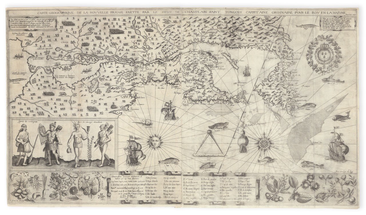
A fine example of the grand two-sheet map from Samuel de Champlain's 1613 Les Voyages du Sieur de Champlain Xaintongeois, perhaps the single greatest American sheet map ever produced.
777 x 450 mm. Engraving with etching on two sheets of early 17th-century laid paper, joined and flattened. A few laid paper repairs mending clean tears on verso. Minor abrasion to two title letters ("PH" in "GEOGRAPHIQUE") discreetly retouched.
Samuel de Champlain completed many vitally important and beautiful maps during his life, but none is as highly regarded, both for its historic cartographic influence and its artful composition, as his Carte Geographique de la Nouvelle Franse. This large two-sheet map dated 1612 and drawn from his voyages of 1603–1611, embraces New France from the New England coast to Labrador and inland along the St. Lawrence toward the Great Lakes. It was conceived for navigation and to advance France’s colonial project at Québec.
The image brims with information and ornament. Québec, Montréal, Tadoussac, the Saguenay, and the Richelieu appear, along with numerous nations and villages. Rhumb lines and soundings structure the Gulf and Grand Banks, with a radiant sun and compass rose at center. An alphabetical coastal index of forty-four names lines the base. Champlain diagrams compass declination and introduces a chain of large interior lakes, including the first printed Lake Champlain and the earliest naming of Montréal. Panels portray Montagnais and Almouchiquois figures and native plants, with ships, marine life, a beaver, and the royal arms.
Engraved in Paris by David Pelletier for Les Voyages du Sieur de Champlain Xaintongeois (Paris, 1613), the map survives in a single state and is often lacking from the book. It is grounded in Champlain’s own surveys and carefully sifted Indigenous reports, augmented by the most recent European discoveries. The work fixed the hydrographic framework of the St. Lawrence, standardized French toponyms from Gaspé to New England, initiated the mapping of the Great Lakes, and provided the most accurate early delineation of the New England coast, preceding John Smith.
Champlain founded Québec in 1608 and forged alliances with Montagnais and Algonquin communities. His surveys, and the instruments pictured here, guided fur-trade routes and cod fisheries and set the agenda for Hondius, Blaeu, and Sanson.
Fite and Freeman provide this translation of the caption in the upper left corner of the map: I have made this map for the greater convenience of the majority of those who navigate these coasts, since they sail to that country according to the compasses arranged for the hemisphere of Asia. And if I had made it like the small one, the majority would not have been able to use it, owing to their not knowing the declination of the needle.
There is only one state of the map, and it does not appear in any later works. It is very often lacking from the book.
Rarity: the separate map is very rare on the market. The map and book last sold together at Christie's in 2024 (The Library of Ernest E. Keet), for $1,320,500.
Alden & Landis 613/60; Burden 160-161, 166-181; Church 360; JCB (3) II:93; Kershaw, pp.62-5; Lande 116; Sabin 11835; Schwartz & Ehrenberg, pp. 85-8; Streeter sale VI:3630.
Join our mailing list
* denotes required fields
We will process the personal data you have supplied in accordance with our privacy policy (available on request). You can unsubscribe or change your preferences at any time by clicking the link in our emails.