![[Keulen, Gerard and Johannes van, and others], [Composite sea atlas containing 56 detailed charts including 3 manuscript charts], Amsterdam, [Johannes van Keulen and others, 1700-1753, engraved title page dated 1734].](https://static-assets.artlogic.net/w_1600,h_1600,c_limit,f_auto,fl_lossy,q_auto/artlogicstorage/hsrarebooks/images/view/812a213d474e432be10d7b8014374fb1j/hsrarebooks-keulen-gerard-and-johannes-van-and-others-composite-sea-atlas-containing-56-detailed-charts-including-3-manuscript-charts-amsterdam-johannes-van-keulen-and-others-1700-.jpg)
![[Keulen, Gerard and Johannes van, and others], [Composite sea atlas containing 56 detailed charts including 3 manuscript charts], Amsterdam, [Johannes van Keulen and others, 1700-1753, engraved title page dated 1734].](https://static-assets.artlogic.net/w_1600,h_1600,c_limit,f_auto,fl_lossy,q_auto/artlogicstorage/hsrarebooks/images/view/818b4d9e821520e5c975a04b6d5f553fj/hsrarebooks-keulen-gerard-and-johannes-van-and-others-composite-sea-atlas-containing-56-detailed-charts-including-3-manuscript-charts-amsterdam-johannes-van-keulen-and-others-1700-.jpg)
![[Keulen, Gerard and Johannes van, and others], [Composite sea atlas containing 56 detailed charts including 3 manuscript charts], Amsterdam, [Johannes van Keulen and others, 1700-1753, engraved title page dated 1734].](https://static-assets.artlogic.net/w_1600,h_1600,c_limit,f_auto,fl_lossy,q_auto/artlogicstorage/hsrarebooks/images/view/59a494353e37e6b2461854553e91087aj/hsrarebooks-keulen-gerard-and-johannes-van-and-others-composite-sea-atlas-containing-56-detailed-charts-including-3-manuscript-charts-amsterdam-johannes-van-keulen-and-others-1700-.jpg)
![[Keulen, Gerard and Johannes van, and others], [Composite sea atlas containing 56 detailed charts including 3 manuscript charts], Amsterdam, [Johannes van Keulen and others, 1700-1753, engraved title page dated 1734].](https://static-assets.artlogic.net/w_1600,h_1600,c_limit,f_auto,fl_lossy,q_auto/artlogicstorage/hsrarebooks/images/view/0a1543e0feaec0d91edefdf793fbd4e6j/hsrarebooks-keulen-gerard-and-johannes-van-and-others-composite-sea-atlas-containing-56-detailed-charts-including-3-manuscript-charts-amsterdam-johannes-van-keulen-and-others-1700-.jpg)
![[Keulen, Gerard and Johannes van, and others], [Composite sea atlas containing 56 detailed charts including 3 manuscript charts], Amsterdam, [Johannes van Keulen and others, 1700-1753, engraved title page dated 1734].](https://static-assets.artlogic.net/w_1600,h_1600,c_limit,f_auto,fl_lossy,q_auto/artlogicstorage/hsrarebooks/images/view/15f4284b768ead9d9e9e1eba33fdd10bj/hsrarebooks-keulen-gerard-and-johannes-van-and-others-composite-sea-atlas-containing-56-detailed-charts-including-3-manuscript-charts-amsterdam-johannes-van-keulen-and-others-1700-.jpg)
![[Keulen, Gerard and Johannes van, and others], [Composite sea atlas containing 56 detailed charts including 3 manuscript charts], Amsterdam, [Johannes van Keulen and others, 1700-1753, engraved title page dated 1734].](https://static-assets.artlogic.net/w_1600,h_1600,c_limit,f_auto,fl_lossy,q_auto/artlogicstorage/hsrarebooks/images/view/1f8aa72584a8195f0b623bf5e2f00962j/hsrarebooks-keulen-gerard-and-johannes-van-and-others-composite-sea-atlas-containing-56-detailed-charts-including-3-manuscript-charts-amsterdam-johannes-van-keulen-and-others-1700-.jpg)
![[Keulen, Gerard and Johannes van, and others], [Composite sea atlas containing 56 detailed charts including 3 manuscript charts], Amsterdam, [Johannes van Keulen and others, 1700-1753, engraved title page dated 1734].](https://static-assets.artlogic.net/w_1600,h_1600,c_limit,f_auto,fl_lossy,q_auto/artlogicstorage/hsrarebooks/images/view/cd4ddc494fccbea2b81b7cca91ea8b22j/hsrarebooks-keulen-gerard-and-johannes-van-and-others-composite-sea-atlas-containing-56-detailed-charts-including-3-manuscript-charts-amsterdam-johannes-van-keulen-and-others-1700-.jpg)
![[Keulen, Gerard and Johannes van, and others], [Composite sea atlas containing 56 detailed charts including 3 manuscript charts], Amsterdam, [Johannes van Keulen and others, 1700-1753, engraved title page dated 1734].](https://static-assets.artlogic.net/w_1600,h_1600,c_limit,f_auto,fl_lossy,q_auto/artlogicstorage/hsrarebooks/images/view/e46d10d409b15a351497179c42b85c39j/hsrarebooks-keulen-gerard-and-johannes-van-and-others-composite-sea-atlas-containing-56-detailed-charts-including-3-manuscript-charts-amsterdam-johannes-van-keulen-and-others-1700-.jpg)
![[Keulen, Gerard and Johannes van, and others], [Composite sea atlas containing 56 detailed charts including 3 manuscript charts], Amsterdam, [Johannes van Keulen and others, 1700-1753, engraved title page dated 1734].](https://static-assets.artlogic.net/w_1600,h_1600,c_limit,f_auto,fl_lossy,q_auto/artlogicstorage/hsrarebooks/images/view/d7c36c98b9b7ddc8a63e54b319994627j/hsrarebooks-keulen-gerard-and-johannes-van-and-others-composite-sea-atlas-containing-56-detailed-charts-including-3-manuscript-charts-amsterdam-johannes-van-keulen-and-others-1700-.jpg)
![[Keulen, Gerard and Johannes van, and others], [Composite sea atlas containing 56 detailed charts including 3 manuscript charts], Amsterdam, [Johannes van Keulen and others, 1700-1753, engraved title page dated 1734].](https://static-assets.artlogic.net/w_1600,h_1600,c_limit,f_auto,fl_lossy,q_auto/artlogicstorage/hsrarebooks/images/view/7ee4f10854c30a26f9186de23c06e8a6j/hsrarebooks-keulen-gerard-and-johannes-van-and-others-composite-sea-atlas-containing-56-detailed-charts-including-3-manuscript-charts-amsterdam-johannes-van-keulen-and-others-1700-.jpg)
![[Keulen, Gerard and Johannes van, and others], [Composite sea atlas containing 56 detailed charts including 3 manuscript charts], Amsterdam, [Johannes van Keulen and others, 1700-1753, engraved title page dated 1734].](https://static-assets.artlogic.net/w_1600,h_1600,c_limit,f_auto,fl_lossy,q_auto/artlogicstorage/hsrarebooks/images/view/6bc11905f5200fd9bbb1b7ad90dceb10j/hsrarebooks-keulen-gerard-and-johannes-van-and-others-composite-sea-atlas-containing-56-detailed-charts-including-3-manuscript-charts-amsterdam-johannes-van-keulen-and-others-1700-.jpg)
![[Keulen, Gerard and Johannes van, and others], [Composite sea atlas containing 56 detailed charts including 3 manuscript charts], Amsterdam, [Johannes van Keulen and others, 1700-1753, engraved title page dated 1734].](https://static-assets.artlogic.net/w_1600,h_1600,c_limit,f_auto,fl_lossy,q_auto/artlogicstorage/hsrarebooks/images/view/88686761bad191502c2b18dcf1f519f2j/hsrarebooks-keulen-gerard-and-johannes-van-and-others-composite-sea-atlas-containing-56-detailed-charts-including-3-manuscript-charts-amsterdam-johannes-van-keulen-and-others-1700-.jpg)
![[Keulen, Gerard and Johannes van, and others], [Composite sea atlas containing 56 detailed charts including 3 manuscript charts], Amsterdam, [Johannes van Keulen and others, 1700-1753, engraved title page dated 1734].](https://static-assets.artlogic.net/w_1600,h_1600,c_limit,f_auto,fl_lossy,q_auto/artlogicstorage/hsrarebooks/images/view/5023932a5f887909b5ca1d30a16909f7j/hsrarebooks-keulen-gerard-and-johannes-van-and-others-composite-sea-atlas-containing-56-detailed-charts-including-3-manuscript-charts-amsterdam-johannes-van-keulen-and-others-1700-.jpg)
![[Keulen, Gerard and Johannes van, and others], [Composite sea atlas containing 56 detailed charts including 3 manuscript charts], Amsterdam, [Johannes van Keulen and others, 1700-1753, engraved title page dated 1734].](https://static-assets.artlogic.net/w_1600,h_1600,c_limit,f_auto,fl_lossy,q_auto/artlogicstorage/hsrarebooks/images/view/fdf7d534bb6fdc796be2436ce1330985j/hsrarebooks-keulen-gerard-and-johannes-van-and-others-composite-sea-atlas-containing-56-detailed-charts-including-3-manuscript-charts-amsterdam-johannes-van-keulen-and-others-1700-.jpg)
![[Keulen, Gerard and Johannes van, and others], [Composite sea atlas containing 56 detailed charts including 3 manuscript charts], Amsterdam, [Johannes van Keulen and others, 1700-1753, engraved title page dated 1734].](https://static-assets.artlogic.net/w_1600,h_1600,c_limit,f_auto,fl_lossy,q_auto/artlogicstorage/hsrarebooks/images/view/19b847c420cbe612e3f163800c6da638j/hsrarebooks-keulen-gerard-and-johannes-van-and-others-composite-sea-atlas-containing-56-detailed-charts-including-3-manuscript-charts-amsterdam-johannes-van-keulen-and-others-1700-.jpg)
![[Keulen, Gerard and Johannes van, and others], [Composite sea atlas containing 56 detailed charts including 3 manuscript charts], Amsterdam, [Johannes van Keulen and others, 1700-1753, engraved title page dated 1734].](https://static-assets.artlogic.net/w_1600,h_1600,c_limit,f_auto,fl_lossy,q_auto/artlogicstorage/hsrarebooks/images/view/61f10c177937cf22c417ff3662bef900j/hsrarebooks-keulen-gerard-and-johannes-van-and-others-composite-sea-atlas-containing-56-detailed-charts-including-3-manuscript-charts-amsterdam-johannes-van-keulen-and-others-1700-.jpg)
![[Keulen, Gerard and Johannes van, and others], [Composite sea atlas containing 56 detailed charts including 3 manuscript charts], Amsterdam, [Johannes van Keulen and others, 1700-1753, engraved title page dated 1734].](https://static-assets.artlogic.net/w_1600,h_1600,c_limit,f_auto,fl_lossy,q_auto/artlogicstorage/hsrarebooks/images/view/892b6fea2394021018a026bc3fddada0j/hsrarebooks-keulen-gerard-and-johannes-van-and-others-composite-sea-atlas-containing-56-detailed-charts-including-3-manuscript-charts-amsterdam-johannes-van-keulen-and-others-1700-.jpg)
[Keulen, Gerard and Johannes van, and others]
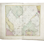
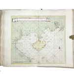
Magnificent contemporary hand-colored composite sea atlas containing 53 detailed printed charts and 3 remarkable, excellently produced manuscript charts of South East Asia. The printed charts were designed by the best chart-makers and originally published by the best Dutch map-publishers of the time, primarily Van Keulen. The original owner has apparently made up his Atlas with the purpose to have all the charts covering the sea-route to the East Indies and beyond, along the coasts of China and Japan. A veritable VOC treasure.
Further images
-
(View a larger image of thumbnail 1
)

-
(View a larger image of thumbnail 2
)

-
(View a larger image of thumbnail 3
)

-
(View a larger image of thumbnail 4
)

-
(View a larger image of thumbnail 5
)

-
(View a larger image of thumbnail 6
)

-
(View a larger image of thumbnail 7
)

-
(View a larger image of thumbnail 8
)

-
(View a larger image of thumbnail 9
)

-
(View a larger image of thumbnail 10
)

-
(View a larger image of thumbnail 11
)

-
(View a larger image of thumbnail 12
)

-
(View a larger image of thumbnail 13
)
-
(View a larger image of thumbnail 14
)
-
(View a larger image of thumbnail 15
)

-
(View a larger image of thumbnail 16
)

-
(View a larger image of thumbnail 17
)


The atlas includes the following charts:
- 38 charts come from Gerard van Keulen's De nieuwe groote ligtende zee-fakkel (originally published in Amsterdam by Johannes van Keulen between 1734 and 1753 in 6 volumes). This atlas is considered to be the masterpiece of the famous Van Keulen family in its best edition enlarged with charts by Schenk and Goos. The Zee-fakkel is the most important sea atlas published in the Netherlands in the first half of the 18th century. The atlas was originally also published in editions with French, Spanish, English, or Italian text. Luxury copies, mostly intended for collector's libraries were assembled to order and the present composite atlas was most definitely produced along these lines. For the specific charts, see Koeman IV: Keu 45, 71, 124F, and 135B (In the present atlas these are charts numbered 2-19, 21, 23, 25-26, 26/2, 29, 32-37, 37/2, 40-42, 45, 48-49, 51).
- 7 large charts come from Pieter I Mortier's Suite du Neptune françois, ou Atlas nouveau des cartes marines (originally published in Amsterdam by Pieter I Mortier in 1700. For the charts, see Koeman IV, M.Mor. 7, but the charts in the present atlas are partly published with engraved numbers not recorded by Koeman, which probably are based on the same charts from a later edition. After the death of Pieter I Mortier in 1711, the copper plates passed to his successors Johannes Covens and Cornelis Mortier. Mortier's Suite also is a very important part of the Neptune françois, and published as a sequel to the parts containing charts of the outer European waters (published in 1693). These 7 Mortier charts are charts numbered 22, 24, 27-28, 30-31 and 43 in the present work.
- 3 charts come from the Covens & Mortier Atlas Nouveau (originally published in Amsterdam by Covens & Mortier in 1741). Charts numbered 38, 39, and 53 come from volume 3 of the Atlas Nouveau.
- 2 charts come from La galerie agreable du monde (originally published in Leiden by Pieter van der Aa in 1729). Charts numbered 50/1 and 50/2 in the present atlas can be found in volume 58 of Van der Aa's work.
- 1 chart is from the Nieuwe Waterwereld ofte Zee-Atlas (originally published in Amsterdam by Caspar Lootsman in 1681). For chart number 52 in the present atlas, see Koeman IV Jac 6, p. 228.
- 2 charts, numbered 1 and 20 in the present atlas, were published separately by Van Keulen; see Koeman IV, pp.386-387.
- Importantly: 3 charts are in manuscript, drawn on paper with pre-printed compass lines and borders (charts numbered 44, 46-47 in the present atlas). The Van Keulen firm supplied pilots of the Dutch East India Company (VOC) and other companies and private enterprisers with manuscript charts to navigate the waters en route to the East Indies. They kept a vast collection of master copies up-to-date, which were used to produce the manuscript charts like those in the present work. The three maps have similar printed counterparts, known under their titles listed below. It is remarkable that these charts were supplied in manuscript, instead of in print, and do not concern the larger scale, and thus more detailed, manuscript charts otherwise more commonly associated with Van Keulen.
Chart 44: [Nieuwe paskaart van de Straaten Sunda en Banca: mitsgaders van een gedeelte van de Nord Kust van Iava en van de Oost Kust van Sumatra als ook de Eylanden Banca en Billeton uyt de nauwkeurigste narichten opgestelt / door Ioannes van Keulen...].
Chart 46: Nieuwe afteekening van de zee kusten van Malacca, Siam, Cambodia, Tiompa, en een gedeelte van de eylanden Borneo en Lucon, strekkende van benoorden het eyland Banca, tot de Pracelas Bank, zijnde een vervolg van de vaarweg na China. Te Amsterdam bij Ioannes van Keulen 't hoek van de nieuwe brug steeg.
Chart 47: [Nieuwe Pas-Caart strekkende van Pta Cataon tot Pta Lamtaon, langs de kusten van Cochinchina, Tonquin, Quangsi en Quantung., bevattende insgelijks het eiland Aynam en die van Macao met dieptens, havens en ankergronden. Te Amsterdam by Ioannes van Keulen Zee-Caart en Boekverkoper op 't hoek van de Nieuw brug-steeg].
Title page and 56 charts. Koeman I, Aa 9; Koeman II, C&M 10; Koeman IV, Jac 6 and Keu 45, 71, 124E, 135B and M.Mor 7; 'In de Gekroonde Lootsman' (Utrecht, HES, 1989), passim.
Join our mailing list
* denotes required fields
We will process the personal data you have supplied in accordance with our privacy policy (available on request). You can unsubscribe or change your preferences at any time by clicking the link in our emails.